How Digital Twin Technology Is Transforming Landslide Monitoring in South Tyrol
Along State Road 12 — one of the main transport corridors connecting Italy and Austria — geological risk is not a theoretical issue. It is a real operational challenge involving infrastructure safety, traffic continuity, and risk management.
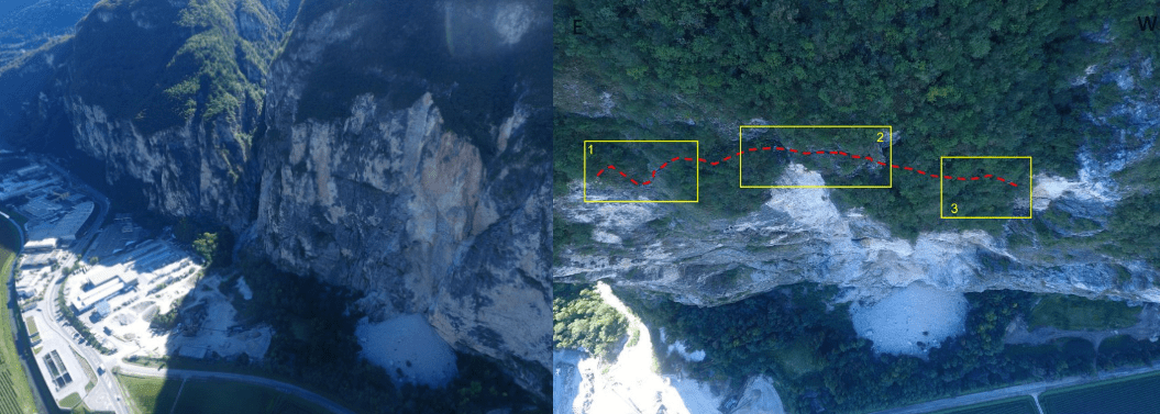
In Salorno (Salurn), the southernmost municipality of South Tyrol, the Geological Service of the Autonomous Province of Bolzano is responsible for monitoring a highly unstable rock slope overlooking this strategic route. In 2012, a major rockslide caused large rock blocks to collapse onto the roadway, damaging a passing vehicle and highlighting the urgent need for more advanced monitoring solutions.
The event marked the beginning of a technological transformation in the way geological risk is managed.
A Large-Scale Geological Challenge
The site presents extremely critical geological conditions. The first recorded rockslide involved approximately 16,000 cubic meters of rock, while the entire unstable rock mass is estimated at around 200,000 cubic meters.
Deep fractures and very steep slopes make the area particularly complex to monitor.
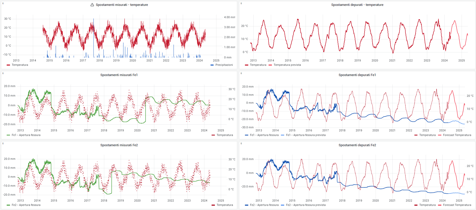
At the beginning, traditional instruments such as inclinometers and extensometers were already installed on site. However, the collected measurements revealed a difficult-to-interpret behavior: the rock wall was moving in response to temperature variations, advancing and retreating depending on seasonal and daily thermal changes.
Understanding the phenomenon required more than periodic inspections and isolated measurements. It required a system capable of continuously interpreting the behavior of the slope over time.
From Traditional Monitoring to a Digital Twin
The collaboration with CAEmate started from this exact need: transforming large amounts of geotechnical data into actionable insight and predictive capability.
The first step was implementing a continuous monitoring system able to collect:
- deformation data;
- displacement measurements;
- environmental parameters;
- rock temperature data.
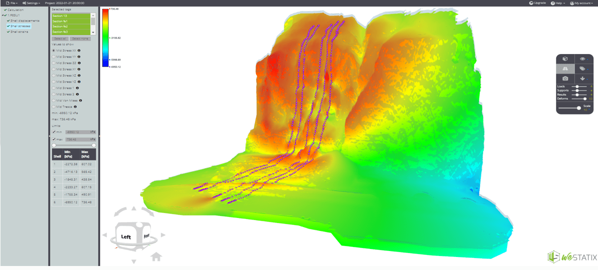
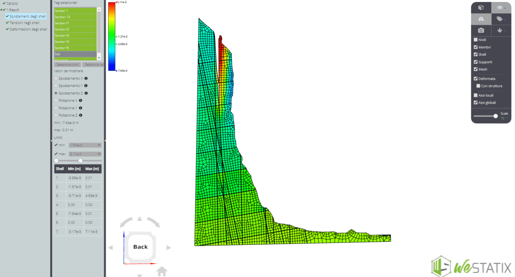
Based on these inputs, a Digital Twin of the rock slope was developed: a dynamic digital model capable of reproducing the behavior of the rock wall in real time.
The system can clearly visualize even millimeter-scale variations within just a few hours, providing an accurate and immediate representation of slope evolution.
When the Model Starts Learning
The most innovative aspect of the project was the transition from simple monitoring to predictive analysis.
The model developed by CAEmate does not simply display data. It learns from the historical and real-time behavior of the rock slope, identifying patterns and correlations that help predict future movements and possible accelerations.
This approach enabled a shift from:
- periodic field inspections;
- manual monitoring activities;
- static geological assessments;
to continuous, minute-by-minute monitoring.
Whenever the data indicates changes in slope behavior, the system allows monitoring frequency to be immediately adjusted, making it possible to detect early warning signs much faster than before.
A New Approach to Geological Risk Management
The Digital Twin enabled a fully data-driven geological assessment process.
Through dashboards, graphs, and real-time analysis, geologists and engineers can observe what is happening on the rock wall as it happens.
The integration of:
- field measurements;
- numerical modeling;
- geotechnical data;
- physical rock properties;
significantly improved the understanding of fracture propagation and overall slope behavior.
The project also strengthened collaboration between geologists and engineers by bringing geological interpretation and technical modeling into a shared digital environment.
Reliable Results Over Time
The project delivered several important outcomes:
- high accuracy in long-term predictive modeling;
- more reliable monitoring-based decision support;
- improved early-warning capabilities;
- continuous validation of the Digital Twin approach.
Since 2023, the monitoring system has been operating continuously without interruptions, collecting real-time data every day through 2026.
For the teams responsible for the safety of a critical infrastructure corridor such as State Road 12, this means faster, more informed, and data-based decision-making.
The Future of Geological Monitoring Is Already Here
Today, landslide monitoring is no longer based solely on field inspections or periodic measurement campaigns.
The integration of sensors, data analysis, and Digital Twin technology is fundamentally changing how geological behavior is understood and managed.
And in high-risk environments such as the Salorno rock slope, this technological evolution is not simply an innovation — it is becoming a new standard for natural hazard management.